

My BRB Mortgage › Streets and subdivisions
Streets, lots and subdivisions
Neighbourhood character is usually discussed as a matter of taste. Most of it is geometry, and the geometry was fixed by whoever drew the subdivision plat. Once the lines are on the ground they outlive the buildings, the owners and often the reasons for them.
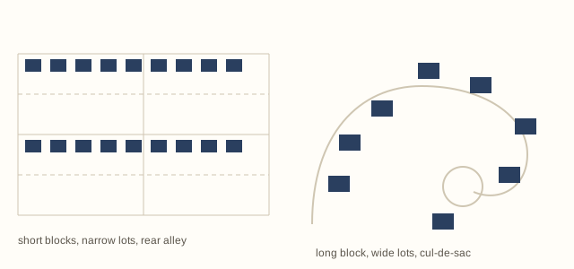
The block
Block length is the single most consequential dimension in a residential layout. Short blocks produce many intersections, many routes between two points, slower traffic and a walkable feel. Long blocks with few connections concentrate traffic onto a small number of collector roads and make walking indirect.
The gridded neighbourhoods of the streetcar era have short blocks because the layout was drawn around walking to a stop. The curvilinear layouts of the post-war decades have long blocks and cul-de-sacs because they were drawn around driving to an arterial. Neither is an accident of style.
The lot
Lot width sets how houses meet the street. Narrow lots produce deep, tall houses with the entrance on the short side, and a rhythm of front doors close together. Wide lots produce houses turned broadside, with the garage becoming a major part of the elevation.
Lot depth sets what can happen behind: outbuildings, additions, later division. Deep lots in old neighbourhoods are the reason those places can absorb change quietly, adding room at the rear without altering the street at all.
Setbacks, and why houses line up
The distance from the property line to the building face is normally fixed by regulation, and it is the reason houses in a given block stand in a row. A uniform setback produces the characteristic corridor of an older street; a varied one produces the looser arrangement of a later suburb.
Side setbacks decide whether a house can be extended sideways, whether a driveway can pass the building, and how much daylight reaches the flank windows. They are among the first constraints any addition meets.
Reading the era from the street
Subdivision eras are legible without documents. Alleys behind the lots, a consistent narrow width and a deep front porch suggest an early twentieth-century layout. Modest single-storey plans on wider lots with a carport and a picture window suggest the post-war decades. Curving streets ending in bulbs, deep front garages and irregular lot shapes suggest the later twentieth century.
Each era carries its own construction and its own recurring questions: what the wiring is likely to be, whether the plumbing has been replaced, how the roof structure spans, what insulation was normal, and what a typical addition of the following decade did to the original plan.
Why the lines outlive everything
Buildings are replaced far more readily than parcels are reconfigured, because changing a boundary requires the agreement of neighbours, a process and, usually, money. So the plat drawn for one purpose keeps governing long after that purpose has gone — mill village lots holding new houses, farm lanes surviving as street alignments, and field boundaries reappearing as the rear lines of a subdivision.